Description
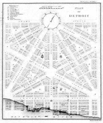
After the destruction of the old French town by fire in 1805 Judge Augustus Woodward devised an unusual triangular plan for rebuilding Detroit. His design for the central portion of the city is shown in this plate prepared for a volume of the American State Papers, Public Lands Series, published in 1860.
This museum quality plan is printed on heavy, cover-stock paper to highlight its lines and shading.
Size: 9 3/4 x 8 1/4 inches. Black & White, Cover-stock Paper
Explore more from our collection.
Reviews
There are no reviews yet.